


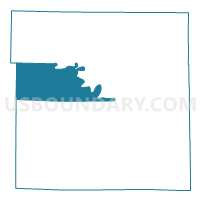
Civil Bend Voting District, Daviess County, Missouri
About
Outline

Summary
| Unique Area Identifier | 607708 |
| Name | Civil Bend Voting District |
| County | Daviess County |
| State | Missouri |
| Area (square miles) | 47.25 |
| Land Area (square miles) | 46.73 |
| Water Area (square miles) | 0.52 |
| % of Land Area | 98.90 |
| % of Water Area | 1.10 |
| Latitude of the Internal Point | 39.99305140 |
| Longtitude of the Internal Point | -94.11096430 |
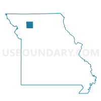
Maps

Graphs
Select a template below for downloading or customizing gragh for Civil Bend Voting District, Daviess County, Missouri


Neighbors
Neighoring Voting District (by Name) Neighboring Voting District on the Map
- Altamont Voting District, Daviess County, MO
- Dallas Voting District, DeKalb County, MO
- Fairview Voting District, Daviess County, MO
- Jameson Voting District, Daviess County, MO
- Pattonsburg Voting District, Daviess County, MO
- Union Voting District, Daviess County, MO
Top 10 Neighboring County Subdivision (by Population) Neighboring County Subdivision on the Map
- Union township, Daviess County, MO (2,137)
- Liberty township, Daviess County, MO (915)
- Benton township, Daviess County, MO (515)
- Jefferson township, Daviess County, MO (506)
- Grand River township, Daviess County, MO (393)
- Dallas township, DeKalb County, MO (336)
- Marion township, Daviess County, MO (225)
Top 10 Neighboring Unified School District (by Population) Neighboring Unified School District on the Map
- Maysville R-I School District, MO (4,187)
- Gallatin R-V School District, MO (3,183)
- Winston R-VI School District, MO (1,225)
- Pattonsburg R-II School District, MO (1,103)
- North Daviess R-III School District, MO (772)